Grey or
White-lines: Lifted
Index solid grey lines > 0 (poor LI values), dashed
white lines<=0degC (moderate or 'good' LI values)
CAPE (Convective Available Potential Energy) See scale at
right of diagram: blue/green - low values of CAPE
, orange/red - high values of CAPE
First note the temperature and dewpoint that is 50 mb above the
surface pressure. Draw a line parallel to the dry adiabatic lapse rate
starting from the temperature that is 50 mb above the surface. Draw a
line parallel to the mixing ratio lines starting from the dewpoint that
is 50 mb above the surface. The intersection of these two lines is the
LCL.
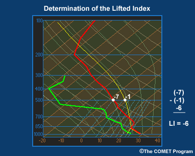
From the LCL, parallel the wet adiabatic lapse rate with height until
the 500 mb pressure level is reached. Compare this 500 mb parcel
temperature to the actual (environmental) 500 mb temperature.
a. The LI only assesses instability in one level of the troposphere.
Unlike LI,
CAPE is better at assessing
instability in the troposphere as a whole.
b. Only use the LI for warm season convection. LI is most relevant in
the warm sector of a mid-latitude cyclone or in a
barotropic
troposphere. LI is worthless when a shallow polar air mass moves into
the PBL and is usually worthless for forecasting winter precipitation.