|


| CIN* (convective inhibition) | <50 | weak cap |
| 50 to 200 | moderate cap | |
| >200 | strong cap |
*CINH (Convective Inhibition in units of Joules per kilogram) is anti-CAPE (negative CAPE) in the lower troposphere. This is the region where a parcel of air if raised from the lower PBL** would sink back down again. ** The planetary boundary layer(PBL) is the lowest layer of the troposphere where wind is influenced by friction.SOURCE:http://www.theweatherprediction.com
|
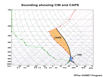
The convective inhibition (CIN) is represented by the area on a skew-T diagram enclosed by the environmental temperature profile and the temperature of a parcel lifted from some originating level to the LFC. This area indicates the amount of energy required to lift the parcel to the LFC. CIN is measured in units of joules per kilogram (J/kg). The larger the negative area, the higher the CIN value, and the lower the likelihood of convective storms. One caveat is that if the CIN is large but storms manage to form, usually due to increased moisture and/or heating overcoming the CIN, then the storms are more likely to be severe. CIN is usually the result of a capping stable layer or inversion, with values of over 200 J/kg significantly inhibiting convective potential. Usually CIN is computed automatically and displayed as output in electronic versions of the skew-T diagram. When calculating CIN, we normally lift a parcel that reflects the mean values of the temperature and moisture in the lowest 50 to 100 hPa. This layer represents the average heat and moisture conditions fueling convective storms.
SOURCE: http://www.meted.ucar.edu |